Keith Balmer
Image by Keith Balmer

Know before you go
Dogs
When to visit
Opening times
Open at all timesBest time to visit
August and SeptemberAbout the reserve
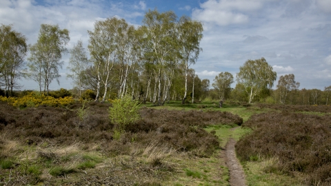
Bedfordshire's largest remaining area of heathland
This reserve, owned by Ampthill Town Council, is a designated Site of Special Scientific Interest. It sits on the Greensand Ridge, a geological feature stretching from Leighton Buzzard to Gamlingay in south Cambridgeshire.
The reserve consists of rare and endangered open heath, patches of gorse and broom and isolated trees, surrounded by pockets of woodland.
Local records indicate that Cooper’s Hill was once known as Ampthill Warren. (The Normans are thought to have introduced rabbits to Britain in the 11th century, and warrens were set up on light soil like this.) Over the years the site was grazed by sheep or cattle and the heather used by locals as fuel, bedding and thatch. Later, conifers were planted here, and then felled in 1917 to help the war effort.
We remove bracken from the open heath to prevent it smothering the heather. Nutrients from fallen leaf litter enrich the soil and encourage the growth of rough grasses which outcompetes the heather, so we thin out the trees and strip back the turf to create bare ground where heather seedlings can flourish.
The northwest corner of the reserve supports a small area of acidic mire and ponds, where the water table reaches the surface above the impermeable Ampthill clay. Marsh violet and willow carr gently shade the water. The open heath provides a home to lizards and to insects such as solitary bees and wasps. Woodland towards the north of the site grows over gently undulating ground, with beech and lime in addition to the birch and oak. Nesting birds take advantage of the protection of the spiky gorse, which gives off its distinctive coconut smell in summer. We run weekly volunteer work parties at Cooper’s Hill.
Visitor survey
We are surveying visitors to this nature reserve to inform our future management of the reserve and develop our community engagement strategy. Please complete the survey after your visit:
Additional information
- Scroll down to see the reserve boundary. Please note the boundary map is for indication purposes only and does not show the Wildlife Trusts definitive land boundary.
FOR ANY MEDIA ENQUIRIES PLEASE CONTACT OUR COMMUNICATIONS TEAM: communicationsteam@wildlifebcn.org or 01954 713500 and ask for comms team.

