Our work is already geared towards building a Nature Recovery Network. Our nature reserves, Living Landscape projects, work with landowners and communities all works to connect landscapes together into a larger network for wildlife to move into and between, and to thrive across our whole landscape. But for our work to be even more effective - to achieve nature's recovery and a Wilder Future - we need everyone to help in the building and maintenance of a Nature Recovery Network with guidelines enshrined in law. The Environment Act (2021) goes some way to providing these, requiring Local Nature Recovery Strategies (LNRS) be produced for every local authority in England. This requires detailed information: where wildlife is abundant or scarce; where it should be in future; which places are most important; and where there is opportunity for positive change.
Wildlife Trusts across the country, in partnership with local authorities and other organisations, have been working on maps such as this for many years, and using them to help guide their work. You can find some local examples further down this page.
If maps like this were used across the country and used by farmers as well as planners the impact for wildlife could be extraordinary.The Wildlife Trusts
Next Steps: Public Consultations
We want our supporters to have their say when Local Nature Recovery Strategy consultations are open for their area, and will update this page as more information becomes available.
The public consultations are all expected to take place in 2024
The North Northamptonshire Local Nature Recovery Strategy consultation is open until Monday 9 December:
North Northamptonshire LNRS Consultation
Update on the one for Cambridgeshire and Peterborough, hosted by Cambs County Council:
Habitat Opportunity Mapping in Northamptonshire
In order to support our work in enhancing and connecting our Living Landscapes in Northamptonshire, we have worked with a wide range of organisations as part of the Nene Valley Nature Improvement Area partnership to produce maps showing opportunities to create new habitats for the benefit of both people and wildlife across the whole of Northamptonshire and Peterborough.
The maps identify potential areas for the expansion of key habitats which are able to deliver particular benefits including biodiversity, the regulation of flooding and air quality, and people's access to green space. They can then be used to assist with the development of green infrastructure strategies and planning, giving decision-makers an evidence-based map to refer to when making these key decisions.
What's been mapped
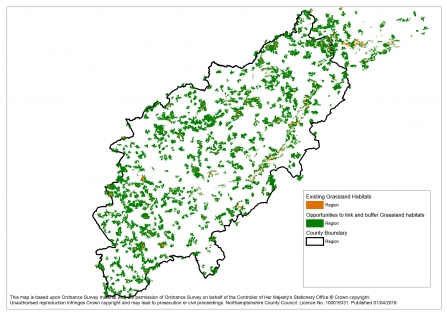
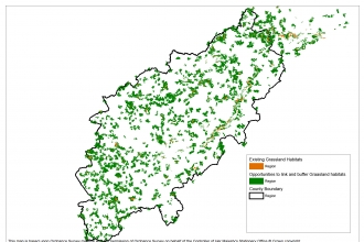
A map showing the opportunities for grassland development in Northamptonshire and Peterborough
Opportunities have been mapped to:
- enhance biodiversity for three different broad habitat types (broadleaved and mixed woodland, semi-natural grassland, and wet grassland and wetland),
- reduce surface water runoff (and hence flood risk),
- reduce soil erosion and improve water quality,
- ameliorate poor air quality, and
- increase public access to natural green space.
The biodiversity opportunity maps highlight areas that are best located in terms of their connectivity to existing habitat patches and are therefore most appropriate from an ecological point of view.
The results
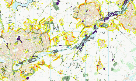
A map of the Upper Nene showing where habitat creation would meet multiple opportunities (e.g. for biodiversity and water quality).
The different opportunity areas vary in their geographic location; the greatest opportunities for reducing water flow are situated to the west of the study area on hillier terrain, whereas water quality opportunities tend to be adjacent to water courses. Air quality and accessible green space opportunities are focussed in and around the major towns.
Broadleaved and mixed woodland biodiversity enhancement is centred around Rockingham and Salcey Forests. The wet grassland and wetlands are focussed on the floodplain of the Middle Nene, whereas opportunities for semi-natural grassland are more spread throughout the area.
In addition to mapping individual opportunities, maps were also combined to highlight opportunities to enhance multiple services simultaneously. Planting woodland and trees, in particular, provides opportunities to deliver multiple benefits (such as reducing surface water runoff and improving air quality). Key locations for delivering these multiple benefits were around the edges of the major towns. Maps showing the combined opportunities for new semi-natural grasslands, and new wet grassland and wetlands were also produced.
Rebuilding biodiversity in Bedfordshire
In Bedfordshire, the Wildlife Trust and Bedfordshire and Luton Biodiversity Recording and Monitoring Centre advised on a Green Infrastructure Plan to provide the foundation for developing sustainable communities across the region.
With the county’s population set to grow significantly, the plan is part of an effort to ensure our environment is protected and sustained for current and future generations to enjoy. Linking with similar plans in adjacent counties, the plan is designed to help create sustainable communities, well served by greenspaces and green routes with access to the countryside on the doorstep.
It is a local demonstration of exactly the sort of work that can be called upon, and built upon, to create a nationwide Nature Recovery Network that is backed up by an Environment Act that ensures organisations and government are legally obliged to ensure it happens.
The vision for Bedford and Luton
The vision is to create a high quality green network across the county for people, places and wildlife, delivering a comprehensive strategic network of multi-functional greenspace and linking corridors.
A number of organisations joined forces to detail the county’s existing green assets and access routes and set out how these assets might be enhanced - and where the creation of new green spaces might best be targeted for the benefit of wildlife and people.
The plan is designed to help shape the county’s future, alongside and integrated with aspirations for housing, transport, employment and economic growth.
What's been mapped
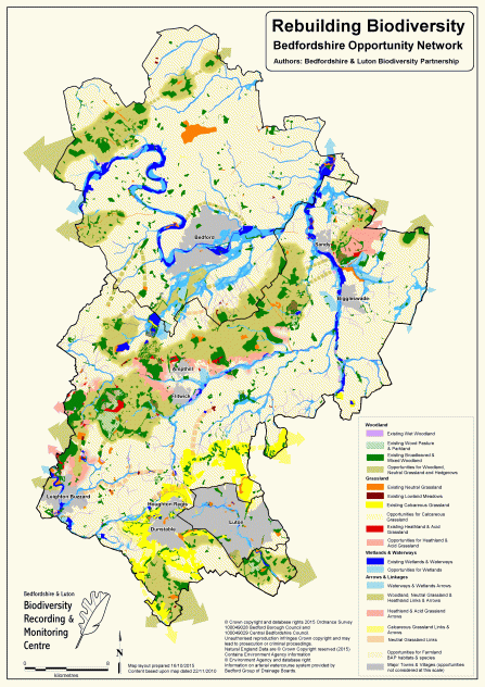
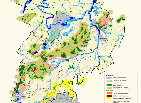
Reproduced here by permission of the Bedfordshire Local Nature Partnership, and originally produced for the Beds and Luton Green Infrastructure Plan
As well as mapping existing green spaces ranging from Sites of Special Scientific Interest to hedgerows, ditches and disused railways, the map also shows a wide range of opportunities for action to enhance the following aspects of our green infrastructure:
- Landscape – conservation and enhancement of important landscapes
- Biodiversity – new habitat creation alongside enhancement and better linkages for wildlife
- Historic environment – improved management, public access and interpretation of heritage assets
- Access routes – improved connections across the county for walkers, cyclists and horseriders
- Accessible greenspace – enhancement of key sites and greenspace creation in areas of deficit
Mapping natural capital and opportunities for habitat creation in Cambridgeshire
In 2019, a report on the habitats of Cambridge, commissioned by the Cambridgeshire and Peterborough Biodiversity Partnership of which the Wildlife Trust and the local Records Centre at CPERC are a part, was published. Using data from many existing sources of digital information, Natural Capital Solutions have produced a report that details the current status of known habitats in the area, and compares this with the information from surveys in the 1930s.
The report contains many maps of different habitats, including those that show potential habitat networks and opportunities which could be used to build a Nature Recovery Network in Cambridgeshire.
An example: Landscape permeability: Broadleaved and mixed woodland species
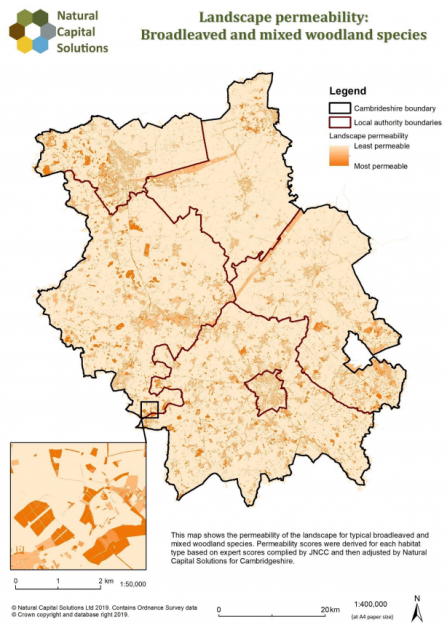
Taken from the Natural Capital Solutions report 2019 on Cambridgeshire Habitat Mapping
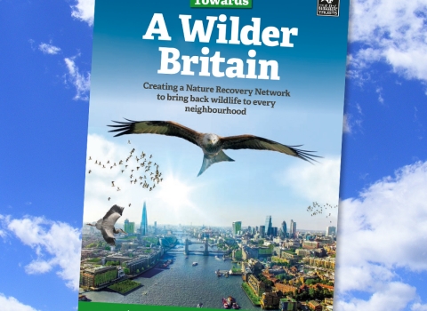
Towards a Wilder Future
Read more about how a Nature Recovery Network could help bring back Britain's wildlife
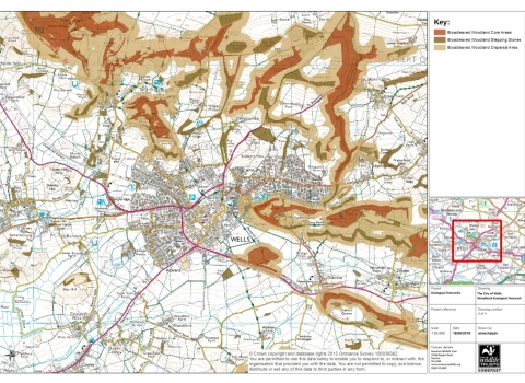
A map by Somerset Wildlife Trust
A national nature map for the UK
Dr Sue Young has outlined how Nature Recovery Network Maps could be created nationwide in this blog for The Wildlife Trusts
