Updating the Ancient Woodland Inventory for Bedfordshire, Cambridgeshire and Northamptonshire

Updating the Ancient Woodland Inventory for Bedfordshire, Cambridgeshire and Northamptonshire

Andy Lear gives a detailed update on the mapping of Ancient Woodland

Ancient Woodland is an important and irreplaceable wildlife habitat home to many rare and threatened species. It is therefore essential that we know where this woodland can be found so that it can be protected. Ancient woodland was first systematically mapped in the 1980s resulting in the production of the original inventory listing sites down to 2 ha in size. The inventory was always called ‘provisional’ and individual areas have been modified but it has become apparent that it needs a systematic update. There are many ancient woodland fragments below 2 ha in size which are at present not recognised by the planning system and modern digital mapping techniques and the wider availability of old maps mean that it is now possible to improve the accuracy of the original inventory.  

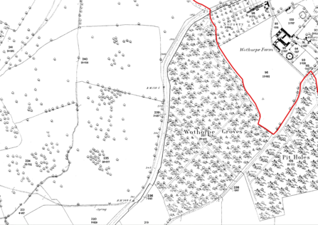
Ancient Woodland in England is defined as having existed continuously since 1600 so updating the inventory has meant delving into old maps. The 1600 date, whilst a rather arbitrary date, was chosen because it marked when the first accurate maps started to be made in this country. The drive to map land accurately came from landowners who wanted to account for their landholdings and these maps were used to support legal documents concerning land sales, purchases and inheritances. As the 17th and 18th centuries progressed parish wide maps were used to delineate the appropriation of commoners’ land, otherwise known as Enclosure, whereby common land and that forming part of the common field system of agriculture was divided up between mainly wealthy landowners. Surveying techniques improved and accurate and detailed county maps began to be produced in the second half of the 18th century with the first detailed mapping of the UK, initially for military purpose, starting around the end of the 18th century. This culminated in the First Series of the Ordnance Survey One-inch to the mile maps being published from the 1820s onwards. The peak of this type of map making came in the second half of the 19th century with the publication of the First Edition of the 25-inch to one mile OS map (Epoch 1), probably the most accurate map of this country ever made before the advent of remote sensing satellite technology.  

Wothorpe Groves AL

Part of a 25 inch to the Mile map showing Wothorpe Groves, Northants. Note this even shows the location of individual field trees! 

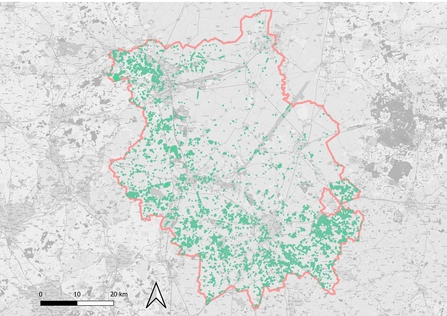
Many of these maps are now available digitally and we have been using them to update the Ancient Woodland Inventories for Bedfordshire, Cambridgeshire and Northamptonshire. The preparatory desk-based stages have been completed. A digital ‘Long-established Woodland’ map layer showing woodland present on current aerial photographs and on the 25” to the mile Epoch 1 Ordnance survey maps has been produced.  

Cambs KF

Cambridgeshire Long-established Woodland map showing woodland present on current aerial photographs and on the 25” to the mile Epoch 1 Ordnance survey maps  

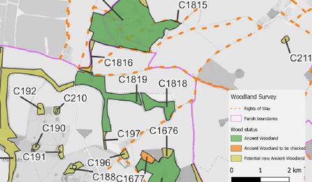
This map layer has then been refined by checking woodland continuity using earlier maps and a list of ‘Potential New Ancient Woodland’ (ie not on the present inventory) has been produced for each county. For more details see here. By using a range of these historical maps, we have also been able to define the boundaries of known ancient woodland more accurately, and to flag up areas of woodland currently considered ancient where more information is needed to confirm its ancient status. In some cases, sites formerly considered Ancient Woodland have been removed because they have been lost to development or agriculture.  

For each of our counties the number of woodland land parcels listed as potential AW is as follows: 

Bedfordshire: 319 

Cambridgeshire: 1650 

Northamptonshire: 886 

Many of these woods are small and are poorly documented. To help confirm their status the next stage of the inventory update is to visit as many as possible and survey them for ancient woodland features and indicators. This a large task and so we have been recruiting volunteers to help with our surveys this spring.

Survey example

A section of the Cambridgeshire survey maps showing the potential Ancient Woodland for surveying 

There are a number of features which can help to identify ancient woodland. Some of these are archaeological, such as boundary banks and ditches. Many medieval woodlands were surrounded by a substantial bank often with a ‘pale’ fence on top to keep deer and other browsing animals out of the wood and prevent the coppice regrowth and regenerating woodland trees from being damaged or destroyed. This was a necessity particularly in the period before the ‘Black Death’ in the 14th century, when cultivatable land and pasture for stock was at a premium, and the woodland resource needed protecting. Such woodland banks can still be seen, they are notably wide with similarly wide ditches unlike the narrow banks and ditches marking later enclosures and fields. Modern drainage ditches, particularly around arable fields can be very substantial, but these have a steep sided profile unlike the older ones.

AL AWI

Woodbank and old coppice stool, Wothorpe Grove, Northants 

Many old woods have a long history of coppice management whereby trees and woodland shrubs (such as hazel) were cut to the ground and then left to regrow for a set number of years - depending on the size of poles required – a form of sustainable woodland management. A consequence is that the coppiced trees and shrubs developed into large ‘stools’ of stems which gradually increase in diameter over many coppice cycles. Large coppice stools are therefore a sign of a long period of traditional woodland management. Where coppicing was abandoned, these stools can grow into large multi-stemmed trees. These are all features found in ancient woodland.  

Tree felling does not preclude a wood being considered ancient as the woodland plants and soil remain. However large-scale clear felling can be detrimental as it removes most of the trees leaving little habitat for species requiring old trees and deadwood. Modern tree harvesting techniques can be particularly damaging because of the impact of large machinery involved. If an ancient wood has undergone felling and has then been left to regenerate naturally and retains native broadleaved trees it is classified as Ancient Semi-natural Woodland (ASNW). Where it is restocked by widespread planting it becomes a Plantation on an Ancient Woodland Site (PAWS). Contrary to the opinion that a felled wood needs to be replanted, most native broadleaved woodland will regenerate naturally provided deer and other browsing animals are prevented from eating the re-growth. Although some replanting probably occurred during the medieval period, with the scattering of acorns to encourage Oak trees, it was during the 17th, 18th and 19th centuries that tree planting became widespread. This was often with non-native trees including conifers and was associated with the creation of large, landscaped parks and grounds designed by the likes of Humphrey Repton and Launcelot ‘Capability’ Brown. Through the 20th century commercial forestry and the establishment of the Forestry Commission lead to large scale tree planting particularly of conifer species such as Norway Spruce, Larch, and Scot’s Pine. This can be particularly damaging to ancient woodland sites.  

As part of the assessment of woodlands we look for signs of planting which range from young trees in plastic tree guards, to trees in rows and the presence of non-native species. How this affects the woodland status depends on the damage done. If the original trees were grubbed out and large-scale ground preparation preceded the planting, then the wood can no-longer be considered ancient. Planting without greatly disturbing the woodland soil would result in the wood being classified as PAWS. Small scale planting mixed with natural regeneration would result in a wood retain ASNW status. This is where a knowledge of native trees species can be useful in assessing woodland. 

The plants growing on the woodland floor are also another useful feature for helping to identify ancient woodland. Many woodland plants have restricted habitat preferences and limited powers of dispersal. The isolated nature of most ancient woodland in southern Britain means that these plants are unable to colonise new sites because the surround farmland is a hostile environment which they cannot cross. There is a suite of characteristic ancient woodland indicator species which we specifically look for when visiting woods.  These species differ slightly between the counties of Bedfordshire, Cambridgeshire and Northamptonshire, but include easily identifiable plants such as Wood Anemone, Bluebell, Wood Sorrel, Woodruff and Dog’s Mercury. Although one or two of these species on their own would not identify a woodland as ancient a large number, particularly if spread throughout the woodland would be highly indicative. 

Dogs mercury - AL

Dog’s Mercury, Mercurialis perennis 

Ancient Woodland is an important and irreplaceable habitat and is protected in the planning system. It is therefore important to make sure the remaining fragments are identified and recorded. The current project in Bedfordshire, Cambridgeshire and Northamptonshire runs until the end of September 2023 (now extended for six months!), so time is short, and we would welcome all the help we can get towards the inventory update to ensure that it is as accurate and thorough as possible.  

If you think you are interested and could identify some, if not all, of these ancient woodland features, we would be interested in hearing from you.  Please contact either Andy Lear (Andy.Lear@wildlifebcn.org for Bedfordshire and Northamptonshire) or Katharine Flach (Katharine.Flach@wildlifebcn.org for Cambridgeshire) for more details.