By working together with other local organisations and landowners the project has been able to cover 12.7km of the river Flit and tributaries plus 40.6ha of adjacent habitat comprising Flitwick Moor Sites of Special Scientific Interest (SSSI), three County Wildlife Sites (CWS) and three non-designated areas of woodland, field edges and ditches.
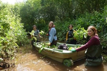
Himalayan Balsam removal on the River Flit

The River Flit Himalayan Balsam (Impatiens glandulifera) Project is an ongoing project which started in 2009 and is proving to still be very successful. The success to date is largely due to the project tackling this invasive species from the most upstream point it occurs, greatly reducing the incidence of re-seeding in previously cleared areas.
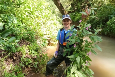
In late 2023 the catchment partnership was successful in obtaining funding from the Anglian Water Invasive Species Fund. The funding covers two years’ work to support the objective of progressive upstream eradication of Himalayan Balsam from the Flit and Ivel Valleys. This has supported staff time in pulling, surveys, and leading volunteer tasks. Funding was also secured by the Environment Agency in 2023 supporting staff time for the management of the project.
As part of the catchment partnership, the WTBCN are responsible for survey and removal activities upstream of Flitton Moor Local Nature Reserve. The 2023 surveys did not cover the full extent of the previous surveys due to an underestimation of the time required. Additional days were therefore scheduled for 2024 and a much larger extent was able to be covered.
The maps below show the results of survey work at 3-year intervals since 2010 (the year of the first full survey), as well as a detailed map of the results from 2024. The animation shows the results from every survey year.

The 2013 and 2019 maps include data from partner organisations such as the Friends of Flitton Moor. The initial survey in 2010 resulted in the use of volunteer work parties to target the most significant patches. As these dominant patches came under control the number of large work parties reduced, with a transition to a small number of staff covering larger sections of the river at each visit. 2019 showed most upstream areas being clear of Himalayan Balsam, however small numbers were still found in difficult to reach areas such as upstream of Priestly Farm (upstream of the confluence to the left of the map) and near Water Lane, Flitwick (red patch just right of centre).
No survey (or removal) took place in 2022 due to a gap between the outgoing water for wildlife officer leaving and the new member of staff starting. This, along with the underestimation of time required in 2023, likely resulted in the resurgence of Himalayan Balsam seen in the 2024 survey. It is also possible that seeds had been spread during recent flood events. It is clearly important that surveys remain consistent due to a combination of the likelihood of missing some plants (which can then set seed), the early production of seed in some plants (which may have set prior to removal) and the germination of seeds in the seed bank from previous years. The flooding in September 2024 likely resulted in the further spreading of seeds and it will be insightful to see what impact this has on the 2025 survey.


The chart below shows the changes in abundance over time as a percentage of the grid squares surveyed, this removes the impact of differences in the number of squares surveyed between survey years. There is a clear drop in the number of dominant and frequent patches between 20210-2016. After this it becomes more difficult to clear remaining patches. It should be noted that surveys in the earlier years targeted specific dominant concentrations, whereas later years concentrated on trying to cover continuous stretches of the river and remove any remaining plants.

It is intended to use the available funding to target contractor work in the most significant areas in the spring/summer of 2025.