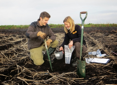
Gathering data from nature reserves
Whilst we work with other organisations - including universities and and local natural history groups - to learn about our nature reserves, we also gather a lot of data ourselves with staff and volunteers. This provides us with essential, targeted information about our different nature reserves.
Our in-house surveys can be divided into three broad types:
1. Species diversity and population trends
Surveying for single species or groups with repeated visits allows us to monitor trends. Many of these surveys provide opportunities for volunteers to get involved, see our volunteering page for more details. These surveys include: Dormice, bats, birds, aquatic insect, butterflies, orchids, and more…
2. Habitat condition monitoring
We periodically assess the condition of our grassland and woodland nature reserves to ensure that our management is on track. Many of our reserves are designated SSSIs and we monitor these to ensure they remain some of the best sites for wildlife. We also utilise modern technology to assist our work, including drones to provide aerial views of our reserves and GIS software to create and analyse detailed habitat maps.
3. Management trials
We have been reviewing our various management techniques and testing new methods to ensure our work is effective. This has included turf stripping, scrub management, woodland ride reprofiling and alternatives to plastic tree guards.
Projects
Birds
Breeding Bird Transects
The purpose of this project is twofold: to keep track of breeding bird numbers and understand which species are using our reserves; and to use birds as indicators of habitat condition. Many bird species are dependent on particular types of habitat for nesting. The structure of the habitat is also important, especially in scrub and woodlands.
This project uses the transect method, by which a recorder walks a fixed path around the site, recording all bird activity along it on a map of the transect route.
The location and number of bird territories found help to provide an assessment of the condition of habitats and to detect any changes brought about by our management. We can also look at trends over time and compare them to national data to understand how species are faring on our reserves compared to in the wider environment.
Wetland Bird Survey (WeBS)
The Wetland Bird Survey is a BTO scheme which uses monthly counts of waterbirds to assess populations and trends in abundance and distribution. It provides particularly valuable information for sites which are legally protected for their importance for waterbirds, such as the Nene Wetlands.
There are WeBS counts on a number of our nature reserves, many of which are done by Wildlife Trust staff and/or volunteers.
Mammals
Dormouse surveys
Nest boxes are used to monitoring known populations of dormice to determine how they are faring and also looking at their dispersal from known sites. Our main project site is Brampton Wood, the location of one of the very first dormouse reintroduction projects in the country, in 1993. Since then, nest boxes have been checked on an annual basis with project expanding throughout the wood and into the surrounding landscape.
As part of this series of projects a new dormouse nest box design was created, The Brampton, which has been successfully used here and on other sites to limit access to the boxes by blue tits. An alternative style developed elsewhere is now being tested alongside the Brampton.
Footprint tunnels are being used at other potential dormouse sites - where we either have only historical records, or no records at all - to look for their presence. The current focus for this is along the edge of their current range in the Rockingham Forest with help from local volunteers.
Bat surveys
Bats are very elusive creatures with specific habitat needs. Evening surveys using bat detectors are carried out at several sites focusing on two important bat habitats – wetlands and woodlands.
Large wetland nature reserves provide a valuable feeding and watering resource for bats of many different species. Bats from a wide geographic area may congregate in large numbers at such sites, providing a valuable opportunity to sample the range of species in such an area, including migratory species, such as the Nathusius’ Pipistrelle. Trees and woodlands are important to all our bat species, for foraging and commuting as well as roosting. Some of our larger wooded reserve clusters have been surveyed in detail by the previous Pathfinder Surveys, but many of our other woodlands are just as important for the bats.
Bat echolocation calls recorded during these surveys and on static bat detectors are analysed back in the office by staff and volunteers.
There is a limit to the information that can be obtained from call data so roost counts, bat box checks and trapping surveys are also carried out. The latter surveys are in collaboration with the Bedfordshire and Cambridgeshire Bat Groups and provides information on sex, age and breeding condition as well as identifying cryptic species.
River mammals
Monitoring the presence of water voles, mink and otters can provide information on the health of our rivers and other waterways. American mink are invasive, skilled predators who have wiped out water voles in many parts of the UK. There is some evidence that the return of otters to a river will displace the mink potentially helping water vole numbers recover. Other efforts are underway to help water vole recovery including targeted releases such as at the Nene Wetlands and widespread mink control by the Waterlife Recovery Trust.
Invertebrates
Aquatic Invertebrates
Aquatic invertebrate communities are monitored at several wetland reserves, focusing on gravel pit edges, scrapes, temporary pools and ditches, including those in the Nene Valley Living Landscape. These ongoing surveys provide an overview of the condition of shallow water features on our reserves and highlight any changes in the aquatic communities which may reflect changes in management or other factors. We also do some targeted survey visits before and after we carry out significant wetland management, so we can understand the impacts on aquatic species.
Butterfly surveys
Butterfly Conservation UK Butterfly Monitoring Scheme transects have been set up on several nature reserves. These are fairly intensive surveys but if you are interested in setting up a new transect on one of our sites please drop us a line.
Species-specific surveys also take place on a number of reserves. In south Bedfordshire chalk grasslands are home to some of the UK's rarer butterfly species. Working with volunteers and university researchers we are able to better understand what species are present on site as well as the best management techniques for them. Volunteers are also monitoring populations of species such as black and purple hairstreaks in woodland and scrub habitats.
Plants
Orchid monitoring
Annual counts of rare orchid species are important for understanding natural fluctuations, identifying population declines and ensuring suitable management occurs to reverse these declines where possible. This includes monitoring populations of man and musk orchids on the North Chilterns Chalk in south Bedfordshire.
Rare Species Guardians
This is a collaborative project between our Monitoring Team, the Bedfordshire Wider Countryside Team and the Bedfordshire Flora Group. Volunteers are helping monitor some of our rarest plant species in the county, checking on them at least once a year and flagging up any potential threats. For more information check out the project webpage here.
Habitats
Heathland management
This project was set up to investigate the success of different heather management techniques at Cooper's Hill nature reserve in an effort to encourage new heather growth and so improve this rare heathland habitat.
The turf-removal trials in particular have been very successful over the short-term with significantly more heather seedlings in appearing. Longer term monitoring indicates that these seedlings have established themselves well and the technique is now being used over larger areas of the site. Long-term monitoring will now occur every 3-5 years rather than annually.
Grassland assessments
This project uses a standardised “Rapid Grassland Assessment” method, set up in 2016, which allows us to consistently compare sites across all three counties and see changes in condition over time. It is carried out on a four year rolling programme on all grassland areas on reserves which are managed, at least in part, for their botanical diversity.
The methods involve taking samples at a fixed number of points along a walk that zigzags across the grassland compartment, recording positive and negative indicator species present, as well as a number of other parameters such as herb to grass ratio and amount of scrub present.
Results each year highlight any potential management issues which can then be addressed, as well as providing evidence of positive changes as a result of previous management. Each site has a bespoke set of targets and the repeated visits every four years allow an assessment of changes in site condition over time.
Woodland assessments
This project is similar to the grassland monitoring, with the aim to highlight changes in site condition over time, and to feed back any management successes and/or potential challenges. There methods involve recording species and other attributes at a set of sample points across the woodland.
Woodland assessments focus on both physical and age structure. Physical structure includes recording how many layers there are in the vegetation: e.g. a ground layer, understorey, sub-canopy, and canopy and how dense or open these layers are. Recording age structure means looking at whether a wood includes seedlings and saplings, through young trees, to mature and veteran trees and both standing and fallen dead wood. Together, these tell us a lot about how healthy a woodland is, and what range of habitats it is providing for animal species.
Abiotic
We also conduct surveys for numerous physical aspects of our sites, this includes:
Drone imaging
Trained pilots use a drone to take aerial images of our nature reserves and produce detailed maps. The aim is to monitor the extent of different habitats. Not all habitat types are easily identifiable from drone images. The method is particularly suitable for monitoring extent of scrub in grassland, and other long-term changes
Water levels
Surveyors take a manual reading of underground water table depth and download from dataloggers. This allows us to monitor hydrological conditions which can influence habitat condition and plant communities.
Soils
We need to monitor the soil chemistry of our grassland features to ensure that management is appropriate. Surveyors conduct a structured walk, stopping at paced intervals to collect soil samples. The soil samples are then sent to a laboratory which provides a full chemical analysis, including pH, potassium and phosphate levels.
Getting involved
If you are interested in helping with some of these surveys by becoming an Ecology Group volunteer or as an individual specialist please email us.
Please visit our general volunteering section for information about other ways you can help the Trust, including other survey work such as River Wardens or Great Fen monitoring.

